INFORMATION ON THEMATIC MAP CALCULATION
In this section you will find the list of categories and information about its calculation, the data source is also reported.
For this page in Italian. Click Here
| # | Name | Data Source | Level | Unit | Coverage | Grouped by Administrative Units |
|---|---|---|---|---|---|---|
| 1 | Accomodation | OSM june/2020 |
EXACT | Number | * | ** |
| 2 | Amenity | OSM june/2020 |
EXACT | Number | * | ** |
| 3 | Education | OSM june/2020 |
EXACT | Number | * | ** |
| 4 | Food | OSM june/2020 |
EXACT | Number | * | ** |
| 5 | Health | OSM june/2020 |
EXACT | Number | * | ** |
| 6 | Bank/Exchange | OSM june/2020 |
EXACT | Number | * | ** |
| 7 | Shop | OSM june/2020 |
EXACT | Number | * | ** |
| 8 | Sport | OSM june/2020 |
EXACT | Number | * | ** |
| 9 | Tourism | OSM june/2020 |
EXACT | Number | * | ** |
| 10 | Transport | OSM june/2020 |
EXACT | Number | * | ** |
| 11 | Australian Population (total population by sex and age) | ABS 2019 |
Statistical Areas Level 2 (SA2) | Number | AUSTRALIA | Yes (SA2) |
| 12 | Austria Population (total population by sex) | HDX 2020 |
GRID | Number | AUSTRIA | Yes (Municipality) |
| 13 | Belgium Population (total population) | STATBEL estimates 2020 |
GRID | Number | BELGIUM | Yes (Municipality) |
| 14 | Czechia, Slovakia Population | WORLD POP HUB 2025 |
PEOPLE per PIXEL | Number | CZECHIA, SLOVAKIA | Yes (Municipality or District) |
| 15 | Denmark Population (total population by sex and age) | DST 2024 |
MUNICIPAL | Number | DENMARK | Yes (Municipality) |
| 16 | Finland Population (total population by sex or age) | STATISTICS FINLAND 2022 |
GRID | Number | FINLAND | Yes (Municipality) |
| 17 | French Population (total population by sex and age) | INSEE 2020 |
MUNICIPAL | Number | FRANCE | Yes (Municipality, arrondissement for Paris,Marseille and Lyon) |
| 18 | Germany Population (total population by sex and age) | STATISTISCHE ÄMTER 2011 |
MUNICIPAL | Number | GERMANY | Yes (Municipality) |
| 19 | Greece Population (total population) | GEODATA.GOV.GR estimates 2020 |
GRID | Number | GREECE | Yes (Municipality) |
| 20 | Italian Population (population by sex, population by age) | ISTAT 2024 |
MUNICIPAL, but normalized with 2021 census data | Number | ITALY | Yes (Municipality) |
| 21 | Italian Average Age | ISTAT 2024 |
MUNICIPAL, but normalized with 2021 census data | Number | ITALY | Yes (Municipality) |
| 22 | Italian Population (total population by sex and age) | ISTAT 2011 |
CENSUS DISTRICT | Number | ITALY | Yes (Municipality) |
| 23 | Italian Average Age | ISTAT 2011 |
CENSUS DISTRICT | Number | ITALY | Yes (Municipality) |
| 24 | Foreigners+Apolides resident in Italy | ISTAT 2011 |
CENSUS DISTRICT | Number | ITALY | Yes (Municipality) |
| 25 | Italian Families | ISTAT 2011 |
CENSUS DISTRICT | Number | ITALY | Yes (Municipality) |
| 26 | Homes in Italy | ISTAT 2011 |
CENSUS DISTRICT | Number | ITALY | Yes (Municipality) |
| 27 | Residential Buildings in Italy | ISTAT 2011 |
CENSUS DISTRICT | Number | ITALY | Yes (Municipality) |
| 28 | Italian Income | MEF 2017 |
MUNICIPAL | Euros | ITALY | Yes (Municipality) |
| 29 | Italian Income | MEF 2018 |
MUNICIPAL | Euros | ITALY | Yes (Municipality) |
| 30 | Italian Income | MEF 2019 |
MUNICIPAL | Euros | ITALY | Yes (Municipality) |
| 31 | Italian Income | MEF 2022 |
MUNICIPAL | Euros | ITALY | Yes (Municipality) |
| 32 | Indonesia, Borneo, Papua Population | WORLD POP HUB 2025 |
PEOPLE per PIXEL | Number | INDONESIA, BORNEO, PAPUA | Yes (Municipality or District) |
| 33 | Netherlands Population | CBS 2022 |
MUNICIPAL | Number | NETHERLANDS | Yes (Municipality) |
| 34 | Norwegian Population | SSB 2024 |
MUNICIPAL | Number | NORWAY | Yes (Municipality) |
| 35 | Portugal Population | INE 2018 |
GRID | Number | PORTUGAL | Yes (Municipality) |
| 36 | England/Wales Population (total population by sex and age) | ONS 2020 |
Lower Layer Super Output Area (LSOA) | Number | ENGLAND/WALES | (Yes) LSOA |
| 37 | England/Wales Average Age | ONS 2020 |
Lower Layer Super Output Area (LSOA) | Number | ENGLAND/WALES | (Yes) LSOA |
| 38 | England/Wales Income | ONS 2020 |
Middle Layer Super Output Area (MSOA) | Number | ENGLAND/WALES | (Yes) Lower Layer Super Output Area (LSOA) |
| 39 | UK Crime | POLICE UK 2018 |
EXACT | Number | UK | (Yes) England/Wales: district. Scotland: surburb. North Ireland: electoral division |
| 40 | UK Crime | POLICE UK 2019 |
EXACT | Number | UK | (Yes) England/Wales: district. Scotland: surburb. North Ireland: electoral division |
| 41 | South Africa Population (total population by group, by income and education level) | STATS SA 2011 |
WARDS | Number | SOUTH AFRICA | (Yes) Local Municipalities |
| 42 | Spain Population (total population) | INE 2018 |
MUNICIPAL | Number | SPAIN | (Yes) Local Municipalities |
| 43 | Sweden Population (total population) | SCB 2020 |
URBAN AREA (TÄTORT) | Number | SWEDEN | Yes (URBAN AREA) |
| 44 | Switzerland Population (total population by sex and age) | STATPOP 2018 |
MUNICIPAL | Number | SWITZERLAND | Yes (Municipality) |
| 45 | U.S. Population (total population by sex) | Census Bureau 2010 |
ZCTA | Number | UNITE STATES | Yes (ZCTA) |
| 46 | U.S. Average Age | Census Bureau 2010 |
ZCTA | Number | UNITED STATES | Yes (ZCTA) |
(*) Iso4app covered countries
(**) Yes if the isoline is claculated in one of the following countries: Australia, France, Germany, Italy, South Africa, Switzerland, UK, USA
Calculation logic based on level
EXACT
Each datum is memorized with the relative GPS coordinate, so the calculation is exact.
CENSUS DISTRICT
The census district is the minimum unit managed by ISTAT. Having demographic data, these are stored with BUILD LINKING logic (see below).
GRID
The population density grids are derived by dividing the population count grids by the land area grid and represent persons per square kilometer.
WARDS
In South Africa, wards are geopolitical subdivisions of municipalities used for electoral purposes.
MUNICIPAL
The data at the municipal level, being referable to the population, are placed on the map according to the population calculated at the census district level, so also the data at the municipal level acquire a good accuracy.
SA2
This is an Australian level. Statistical Areas Level 2 (SA2) are medium-sized general purpose areas built up from whole Statistical Areas Level 1. Their purpose is to represent a community that interacts together socially and economically.
ZCTA
This is an U.S.level. ZIP Code Tabulation Areas (ZCTAs) are generalized areal representations of United States Postal Service (USPS) ZIP Code service areas.
PEOPLE per PIXEL
We adhere strictly to what has been developed by WordPop Hub, without adding any internal logic. If you use this type of population distribution (i.e. population placement on the map), please read the recommendations and warnings provided on WordPop Hub.
BUILD LINKING
For each census district, from the map the residential buildings are read and their size are estimated. At the end of this calculation each building will have a weight in relation to the other buildings of the same census district.
In addition, on all residential areas, the system creates fictitious buildings equally distributed in it.
Having the population data for the census district this will be distributed on the buildings in relation to their weight.
Given that by now the cartography reports with good accuracy the buildings on the territory this methodology gives an excellent precision. In the case in which the census district indicates a population, but for the same the cartography does not show any building (it can happen in isolated areas of the countryside) the system, in order not to lose these values, creates fictitious buildings equally distributed in the census district.
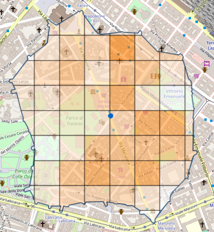
As you can see in the following example image the areas with fewer houses, parks or squares, are those with a lighter color, so with low population density.

GROUPING DATA BY ADMINISTRATIVE REGIONS
The system in some countries provides a grouping by administrative regions, both graphical and table formats.
The type of administrative region depends on the country in which the thematic map is requested, even if it is typically a municipal grouping.
So in addition to having information on the general total, you will have information on the total for each administrative region (share part) intersected by the polygon that represents the isochrone/isodistance
Below the screenshots:
Thematic map (Catchment Area) with England population and administrative regions grouping.

By moving the mouse over the click PIN an information window is shown and you can find the total population under the polygon.

By moving the mouse over a municipality represented in the table, the corresponding municipality boundary lights up on the map.

HOW TO SHOW A THEMATIC/CATCHMENT AREA
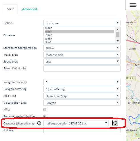
The thematic map can be selected from the menu as shown in the screenshot below. Then proceed with the click on the map in the desired analysis point. To reapply a different thematic map on the point already present on the map, you can use the icon to the right of the categories: ![]()

Our developers can support you in case you need to have these features directly integrated into your systems. Please contact us.
A short guide in Italian.
Eine kurze Anleitung auf Deutsch.
Un petit guide en Français.
Een korte handleiding in het Nederlands.
Una breve guía en español
A short guide in English